Worked Example: Information for Municipal Monuments
Worked example illustrating the methodology behind the Delft Municipal Data Model (Dutch: Gemeentelijk Gegevensmodel, abbreviated GGM).
Municipal Monuments
With about 1,500 protected monuments, Delft is in the top 10 of monument cities in the Netherlands. The city centre has international fame, but the monument policy also covers areas outside the centre. Cultural-historical values are protected in various ways.
In addition to municipal and national (rijks) monuments, Delft has four nationally protected city views — the city centre, the Nieuwe Plantage, the Agnetapark and TU-Noord. The municipality has also designated thirteen so-called Green Pearls: green areas protected through the local zoning plan.
The statutory tasks of the monument advisors focus on protection and preservation, yet most of the work consists of continually responding to developments and changes in the physical living environment. How can we adapt buildings and areas so the cultural-historical values are preserved while they remain functional? Whether for a new use or for sustainability, dealing with monuments is always bespoke — no two monuments are the same.
Over time the work area of the monument advisors has broadened to cover the entire heritage spectrum where the physical environment is concerned. Of course there are objects where preservation always comes first — think of the City Hall, the canals — but the advisors are also involved in area developments. The cultural-historical values then provide a framework on which to build further. What are the characteristics of the area, and which are worth preserving? Which stories do we want to tell — not only us, but the whole city? Heritage is the means par excellence for engaging in dialogue, for connecting, for feeling at home. With this, Delft follows the national track towards the Environment and Planning Act, in which heritage is formulated as a valuable environmental quality.
The Delft policy on monuments is described in:
- Monumentennota 2007–2017
- Monuments Bylaw, Municipality of Delft
- Welstand policy and quick-test criteria (incl. Welstandsnota Delft)
- Bylaw on the Welstand and Monuments Committee
- Implementation Guidelines Monument Care Delft
- The History/Cultural-history section of all adopted zoning plans.
- The Heritage Memorandum (Erfgoednota).
The municipality's monument policy is carried out by a team of monument advisors within the Heritage department. While the archaeologists in the same department deal with subterranean cultural history, the monument advisors are responsible for careful handling of the above-ground cultural-historical values of the city. They deal with:
- Statutory tasks
- Overseeing careful handling of monuments.
- Overseeing careful handling of protected city views, including public space (street layout, bridges, paving).
- Valuation of cultural history in zoning plans.
- Valuation of cultural history in area developments.
- Permit issuance for building plans, both for national and municipal monuments (under the WABO and soon the Environment and Planning Act).
- Supervision and enforcement of issued permits.
- Maintaining the municipal monuments registration (currently in Mon4All), containing both national and municipal monuments.
- Advice — internally, to monument owners and to the public.
- Building-historical research to map cultural-historical values.
- Issuing decisions on subsidies and financing for monuments.
- Participation — receiving (city dialogues) and as partner in citizen initiatives.
Several buildings within the Municipality of Delft have a protected status. This may be because national protection has been granted (then called a rijksmonument) or because the municipality has granted protection (then called a municipal monument). Granting municipal-protected status proceeds via a so-called designation description.
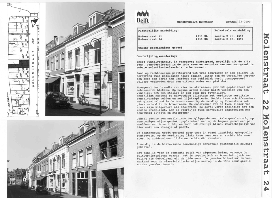
Diagram (in Dutch): example of an "Aanwijsbeschrijving" — the formal designation description by which the municipality grants protected status to a building or area.
Applications and policy domains
The Monuments department uses the following administrations:
- Mon4All — administration of objects and areas with protected status. Mon4All is up for replacement.
- Suite4Omgevingsdiensten — permit issuance. Also up for replacement, in the context of the introduction of the Environment and Planning Act.
- GIDS — monuments, protected city views and protected green areas on the map, as well as historical map layers.
- Verseon — recording all official communication.
- delft.nl/monumenten — publication of the regulations.
- A drive with an extensive folder system, organised by object, street, area, etc., for storing documentation for permit applications, building-historical information and photos.
- A drive shared with VTH (permits, supervision, enforcement) for storing documents related to OLO applications, bridging the gap between the front office and the archive.
- Worklist — an Excel file with current permit applications, VJVs and collegial advices.
- Enforcement list — an Excel file with all enforcement cases.
- OLO — the monument advisors (both for permit issuance and supervision) work directly in the OLO (Omgevingsloket Online) to handle incoming documents. Because OLO is not equipped for this and is occasionally barely accessible, the additional overview lists/folders are used.
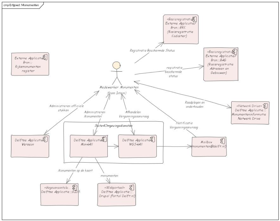
Diagram (in Dutch): the application landscape used by the Monuments department.
Monuments staff register objects and areas with monument status in Mon4All. Mon4All is part of Suite4Omgevingsdiensten. The data captured includes:
- Location (address and coordinates).
- Cadastral data.
- Type of monument: national (rijks), municipal, culturally-historically valuable.
- Type of area: protected city view (per address).
- Building-historical value/expectation (per address and based on research, e.g. old core, old building-historical traces).
- Substantive characteristics (year of construction, function, architect, craftsmanship).
- Photos and documents (for municipal monuments the designation document is often added as a
.jpg). - Designation description — the official statement of designation as a monument, usually including a drawing of the parcel.
Mon4All has no automatic link to BAG (addresses/buildings) or BRK (cadastre).
From Mon4All, monument information is published to GIDS (for map display) and to the municipal website. Protected city views are registered per address in Mon4All; in GIDS they are visible as polygons. National monuments are administered in the National Monuments Register — the official, current register of nationally protected objects and areas, and the source for the national-monument data in Mon4All. It is essentially an exact copy; however, the municipality is more precise about coordinates of protected objects.
In Suite4Omgevingsdiensten (WGS4All), in collaboration with other departments including VTH, building permits are processed — both for municipal and national monuments, culturally-historically valuable buildings, and the redesign of green areas (felling and laying-out permits).
The drive with documentation for permit applications, building-historical information and photos contains person-related information and is unsuitable for publication. In Verseon, all official documents are stored, such as issued permits and granted loans.
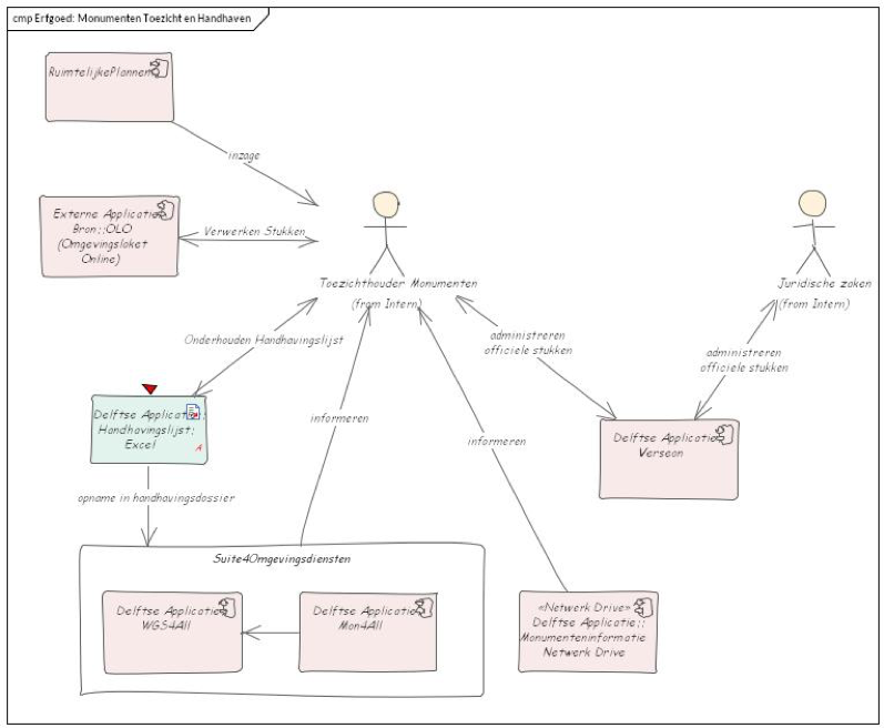
Diagram (in Dutch): supervision and enforcement workflow within the Monuments department.
In the supervisory role within Monuments, OLO is used for sending and receiving documents to/from permit applicants. Objects under supervision are recorded in the enforcement list and copied into Suite4Omgevingsdiensten. All official documents are stored in Verseon. Where enforcement is required — for example when a penalty is imposed — this happens in collaboration with the Legal Affairs department.
Applications and data
The next figure shows the authoritative sources with their data. WGS4All as part of Suite4Omgevingsdiensten is omitted because it is covered in the VTH elaboration, in line with case-oriented working.
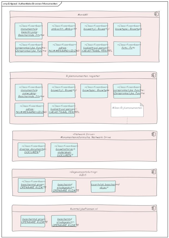
Diagram (in Dutch): applications used in the Monuments domain together with the data each holds.
The figure shows the (necessarily) duplicate registration in the National Monuments Register and Mon4All — see Observation. Mon4All can store more attributes and, alongside national monuments, also tracks municipal monuments. It also shows how protected green areas are stored in GIDS, even though GIDS is intended only for displaying information; the protection of green areas is arranged in the zoning plan, which is found in Ruimtelijkeplannen.nl. GIDS holds protected green areas and protected city views, and is the only source for the contours of objects with protected status.
Data definitions
At the heart of the Monuments entity model is Protected Status, which holds the data and relationships registered for a monument — beyond the data already in BAG (Base Registration of Addresses and Buildings) and BRK (Cadastral Base Registration). The next figure shows the relationship with these base registrations.
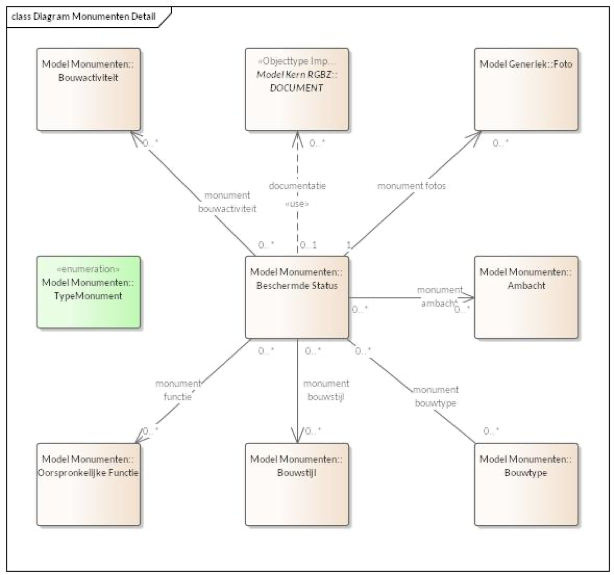
Diagram (in Dutch): the entity model around "Protected Status", showing relationships to BAG and BRK base registrations.
Protected Status contains items such as: national-monument code and/or municipal-monument code, date of inclusion in the register, description and type of monument. Linked to Protected Status are (with attributes per linked entity):
- Building activity (0 or more): year-from, year-to, indication, description.
- DOCUMENT (0 or more): all documents belonging to the monument.
- Photo (0 or more): all visual material of the monument.
- Craftsmanship (0 or more): kind of craft applied to the monument, year-from and year-to.
- Building type (0 or more): main category, sub-category and explanation.
- Building style (0 or more): main style, sub-style, purity and explanation.
- Original function (0 or more): function, function type and main function, main category, sub-category and explanation.
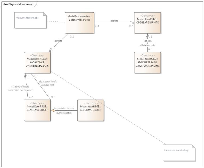
Diagram (in Dutch): data definitions for Monuments and their links to the core entities of the GGM (KADASTRALE ONROERENDE ZAAK and Openbare Ruimte).
A Protected Status may concern one or more Cadastral Real Estate objects, and may also concern one or more Public Space objects (e.g. a (part of a) street or a piece of greenery). Both Cadastral Real Estate and Public Space originate from the RSGB and are linked to the BAG, so they can be related to information from the base registrations. The RSGB terminology has been retained here to align with the rest of the GGM and the base registrations.